Las Vegas sits atop the Las Vegas Valley, a basin filled with thousands of feet of alluvial sediments from the surrounding Spring and Sheep Mountain ranges. These unconsolidated deposits, primarily sands, silts, and gravels with varying densities, create complex velocity gradients that challenge standard geotechnical investigations. Seismic tomography (refraction/reflection) addresses this by generating high-resolution P-wave and S-wave velocity profiles down to depths exceeding 100 feet, mapping lateral and vertical changes that influence foundation design, seismic site classification per ASCE 7, and fault hazard assessment across the valley floor from Summerlin to Henderson.
The alluvial basin beneath Las Vegas requires seismic tomography to map velocity inversions that standard borings miss entirely, especially near fault zones.
Service characteristics in Las Vegas
Critical ground factors in Las Vegas
Las Vegas averages over 300 days of sunshine annually, yet its subsurface hazard is anything but benign. The valley records an average of one magnitude 4.0 or greater earthquake every 5 to 7 years, and the underlying Basin and Range extension creates active fault systems such as the Eglington fault. Relying solely on point borings risks missing a shear-zone velocity low or a hidden paleochannel filled with loose sand that could amplify ground motion. Seismic tomography (refraction/reflection) addresses this by producing continuous velocity profiles across the site, revealing anomalies that a sparse grid of SPT holes would overlook, ultimately reducing the uncertainty in seismic site class assignments under ASCE 7.
Our services
We tailor seismic tomography packages to Las Vegas project scales, from small commercial lots to large infrastructure corridors.
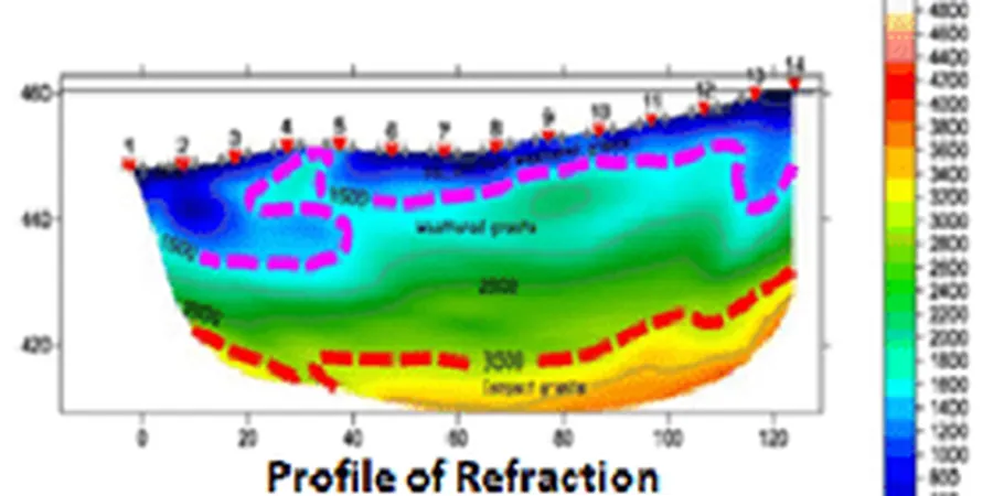
2D Refraction Tomography
High-resolution P-wave velocity imaging using first-arrival travel time inversion. Ideal for mapping the top of rock, depth to groundwater table, and delineating weathered zones in the alluvial sequence common to Las Vegas.
Multichannel Analysis of Surface Waves (MASW)
Shear-wave velocity profiling for Vs30 determination and seismic site classification per ASCE 7. MASW complements refraction tomography by providing a direct measure of the soil stiffness profile.
Reflection Seismic Profiling
Deep structural imaging for fault detection and stratigraphic mapping. Useful near the Eglington fault zone or where deeper basin geometry influences foundation response in high-rise developments.
Frequently asked questions
What is the typical cost range for seismic tomography in Las Vegas?
For a standard 2D refraction survey covering 200 to 400 linear feet with 24 channels and one accelerated weight drop source, the cost typically ranges between US$2.550 and US$4.820. Larger projects, multiple lines, or reflection profiling can increase the price based on mobilization and data processing complexity.
How deep can seismic tomography see in Las Vegas alluvium?
In the loose to medium-dense alluvial sands and silts of the Las Vegas Valley, refraction tomography with a 140 kg weight drop can achieve depths of 30 to 50 meters. Reflection surveying may reach 100 meters or more in favorable conditions, though the shallow velocity inversion at the water table (typically 30 to 60 feet deep) can reduce penetration if not accounted for in processing.
Do I need seismic tomography if I already have SPT borings?
Yes, especially in Las Vegas where the alluvium is laterally heterogeneous. SPT borings provide point-specific blow counts, but seismic tomography fills the gaps between boreholes, revealing velocity contrasts that correlate with changes in density, cementation, or the presence of paleochannels. The combined dataset reduces the risk of missing a weak layer that could control foundation performance under seismic loading.